
Driver location signs
| METRICATION: 90% complete | |||
 |
|||
| Metric | Non-metric | ||
| Distance marker posts in kilometres | Junction names don’t use metric distance information | ||
| Driver location signs in kilometres | |||
Distance marker posts
Since at least the 1970s, motorways have had distance marker posts installed at 100 metre intervals at the edge of the hard shoulder. They are also installed alongside many all-purpose trunk roads.
Distance marker posts provide location reference points which are used by road maintenance and emergency services. For drivers that become stranded, they are also marked with an arrow pointing in the direction of the nearest emergency telephone.
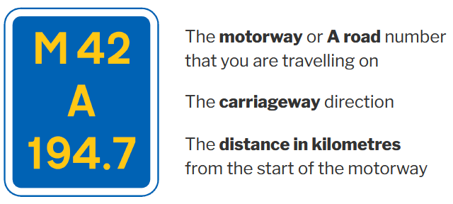
The numbers on the post show the motorway or road number, the carriageway (in standard highways parlance of ‘A’ away from London, and ‘B’ towards London, or in the case of the M25, ‘A’ for clockwise and ‘B’ for anticlockwise), and a zero reference point which is the distance from the designated start point of the road in kilometres, to one decimal place.
Driver location signs

A distance marker post and driver location sign at kilometre 409.5 on the A38 – 2009
By the early 2000s, drivers were increasingly relying on their mobile phones for contacting emergency services on motorways, rather than making use of less convenient roadside emergency telephones.
This meant that the driver location information which was previously relayed automatically by the roadside phones, was now having to be provided by drivers themselves.
The location information on distance marker posts is not always easy for drivers to find, especially at night. Reading the marker posts usually necessitates getting out of the vehicle. The Highways Agency realised that a new approach was needed.
In 2003, newly designed driver location signs were installed on the M25 on an experimental trial basis. Signs were installed at 500-metre intervals. In common with the distance marker posts which they complement, locations were shown in kilometres to one decimal place.
Driver location sign design
Following the success of the 2003 trial, on 1 March 2007, The Secretary of State for Transport signed the authorisation necessary for the installation of driver location signs on motorway and all-purpose trunk roads throughout England.
There was very little publicity about the new signs. However, a public information leaflet was published by the Highways Agency in 2007, which was updated in 2008.
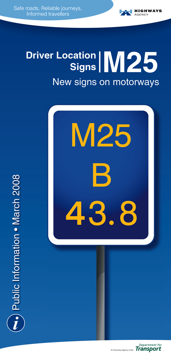
A Highways Agency public information leaflet – 2008
By 2010, driver location signs had been installed throughout the English motorway network, and on many A-roads.
Sign specifications
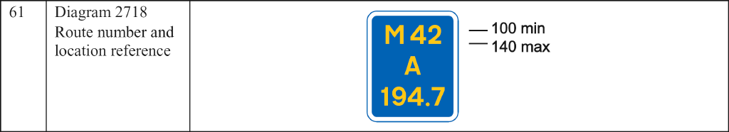
TSRGD, Section 11 Part 2 – 2016
The current design and implementation requirements for driver location signs are specified in CD 193 Driver location signs, published by Highways England. In 2016, driver location signs were also added to the Traffic Signs Regulations and General Directions. Together, these regulations apply to the whole of the UK. However, as of 2026, driver location signs have yet to be installed on motorways in Scotland or Wales.
The Highway Code
On 14 September 2021, Rule 277 of the Highway Code was updated to include images to ensure that readers understand how to use distance marker posts and driver location signs to identify and communicate their location to emergency services.
Highway Code – Rule 277 (extract) – 2021
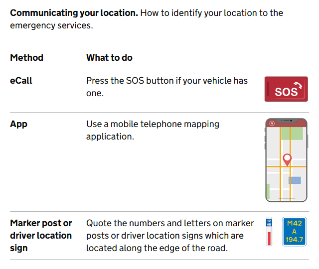
Of the three methods listed in Rule 277 for identifying a location, the only one that does not require access to a sophisticated electronic device is the one where the values on driver location signs, or marker posts, are quoted.
Rather than just being able to quote the numbers and letters on the signs, knowing what they mean can aid understanding when communicating a precise location in an emergency. For example, the location given in the illustration can be quoted as being “at kilometre 194.7 on carriageway A of the M42 motorway”.
Motorway junction names
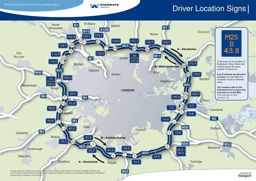
A Highways Agency map showing the kilometre locations of junctions on the M25 – 2007
Motorway junctions in the UK have historically been named according to the order of their occurrence from the motorway’s start point. Thus the first junction along the ‘A’ carriageway would be named ‘J1’, and the next junction ‘J2’, and so on. This method of naming junctions has three notable shortcomings:
- The junction name provides no inate distance information. It is not possible to know the distance between one junction and the next.
- When new junctions need to be added to an existing road, the number sequence breaks down and supplementary letters are needed, e.g. J10A on the M6.
- Junction numbers create an imprecise secondary location method, that is incompatible with the kilometre-based system used for distance marker posts.
Metrication of motorway junction names
All of the shortcomings of the current motorway junction naming system can be addressed by the adoption of metric junction names:
- For instances where the letter ‘J’ is currently used, and to make a distinction from the old naming system, new junction names could use the letter ‘K’. This would also serve to indicate that the junction name refers to its kilometre position. The numerical part of the junction name would then simply be the whole number part of the nearest distance marker post’s kilometre reference. The distance in kilometres between one junction and the next could be found simply by subtracting the smallest junction number from the largest.
- When new junctions are needed, they can be named without any need for supplementary letters.
- The same location reference system can be used for both junction names and distance marker posts.
There is nothing preventing the Department for Transport from upgrading motorway junction naming regulations to use the same kilometre location reference system as driver location signs before other road signs switch to metric units. However, savings would be made if junction names are changed at the same time as the metrication of distance signs on motorways.
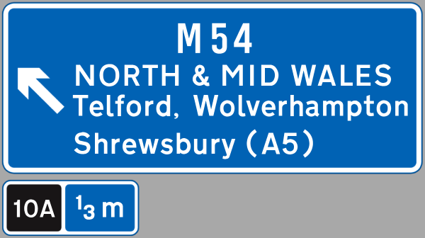
| CURRENT SIGNS | METRIC SIGNS |
 |
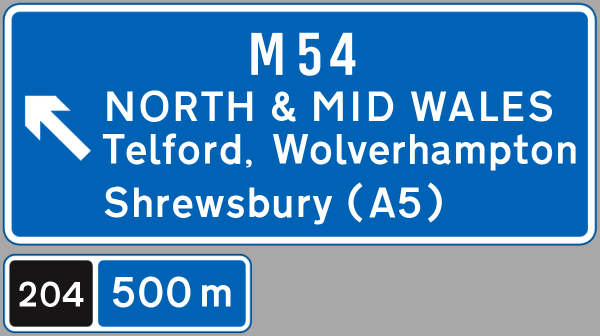 |
| M6 junction 10A, or J10A | M6 junction 204, or K204 |
The adoption of a metric junction naming system will bring additional benefits that are not possible with the current naming system:
- Driver location signs will be imparted with an extra use. Their use will no longer be restricted to emergencies. Driver location signs will be useful as countdown markers to a driver’s destination junction.
- As drivers become familiar with the new metric names of the junctions in their locality, they will also be learning the distances in kilometres between these places.
Some examples of motorway junctions using metric junction names
| M6 | M25 | |||
| Current name | Metric name | Current name | Metric name | |
| J21 | K302 | J16 | K102 | |
| J21A | K306 | J17 | K110 | |
| J22 | K309 | J18 | K112 | |
| J23 | K314 | J19 | K116 | |
| J24 | K316 | J20 | K118 | |
| J25 | K318 | J21 | K122 | |
| J26 | K322 | J21A | K123 | |
| J27 | K329 | J22 | K129 | |
| J28 | K341 | J23 | K134 | |
In the examples above, using the metric junction names alone, it can be deduced that the distance between junctions K329 and K341 of the M6 is 12 km. The existing junction naming system does not provide this benefit.
TOP TIPS :
Use driver location signs to learn the kilometre numbers of motorway junctions that you use. If you know the kilometre number of your exit junction, you can reduce the likelihood of missing your exit by using driver location signs to count down the distance.
Use driver location signs to familiarise yourself with kilometres. With driver location signs positioned every 500 metres, it is quite easy to see 2 signs ahead on a straight stretch of motorway. A distance of one kilometre is much easier to visualise than one mile.
FUN FACT :
At a speed of 100 km/h, you will be travelling at one kilometre every 36 seconds. On motorways in England, at 100 km/h, you should be passing one driver location sign every 18 seconds.
